The RTA has released its route options for the Pacific Highway in the Clarence valley. If
you’re at all interested in the floodplain, or creeks, or wetlands, or trees, or wildlife, or
farms, or the peaceful lives of local folk, please take the time to either call into the RTA on
the corner of Prince and Victoria Streets and check out the details, or look at the highway website.
The RTA engineers might dream of a straight line between Wells Crossing and Iluka. But
they’re having to weigh up social, environmental and economic costs. No-one knows how
these costs might be weighted. The fundamental issue of sustainable transport patterns is
not on the table, so it’s not much use raising it. The only hope is that by the time they get
around to building this highway, we might have to be doing things differently as a society,
and superhighways might have become dinosaurs. The RTA has come up with four options
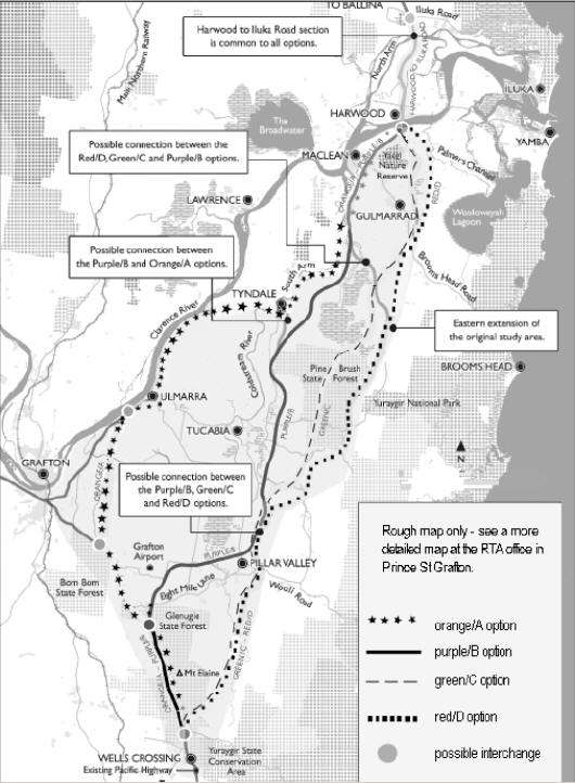
for public comment. Here’s a brief description of each one. All options bypass Grafton and
include a new Harwood Bridge.
The Orange/A option (coloured orange on the map) is the most western option. It
basically follows the existing highway, but it deviates to the east between Bom Bom State
Forest and Swan Creek. This means it would run just east of Four Mile Lane, cutting past
Clarenza. It would bypass Ulmarra and Tyndale.
The Purple/B option follows the existing highway from Wells Crossing to the northern
end of the Glenugie State Forest (the Wooli turn-off). It then runs to Pillar Valley before
heading north, keeping to the west of Pine Brush State Forest and to the east of Chaffin
Swamp. It passes to the west of Tyndale Swamp (a SEPP 14 wetland), before re-joining the
existing highway route just north of Tyndale.
The Green/C option deviates from the existing highway just north of Wells Crossing. It
runs north, crossing the Wooli Rd at Pillar Valley. It heads north through the middle of Pine
Brush State Forest, runs through Tyndale Swamp through the Gulmarrad rural residential
area, through the James Creek area and on to the Harwood Bridge.
The Red/D option is the most eastern of the options. It deviates from the existing highway
just north of Wells Crossing and runs to Pillar Valley, same as option C. But from Pillar
Valley it heads north-east along the eastern edge of Pine Brush State Forest. It runs east of
Tyndale Swamp, east of Gulmarrad and up to Harwood Bridge through the James Creek
area.
The purple, red and green options are likely to have the greatest ecological impacts (but
they will all have an impact). The green option is the most obviously bad, and may
represent a kind of bad cop. The orange option is likely to have the least ecological impact.
There’ll be a lot of hot arguments about this piece of infra structure, because,
understandably, no-one will want the highway anywhere near their house or farm. It’s a
terrible thing when your home is threatened. Wildlife east of the existing highway should
be very worried about loss of their habitat and their ability to move between areas,
particularly from the floodplain to the coastal range. If you care, please have a close look at
the RTA maps and report, and write a letter before 2nd December to
(1) Floodplain would have to be built up 2-3m to protect against a 1 in 20yr flood. -Mark, Claire
Community Liaison Manager
Evonne McCabe,
Sinclair Knight Merz,
PO Box 164,
St Leonards NSW 1590.
Fax: 02 9928 2502 (Marked: Attention - Wells Crossing to Iluka Road Project)
or
Email: [email protected]
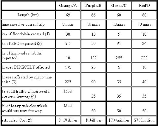
(2) EEC = Endangered Ecological Communities
(3) Most of these houses in Orange/A option are already affected by current highway noise,
and many of them will be the 175 in the new road reserve and have to be
acquired/demolished, but no distinction is made in the RTA report.
(4) Most traffic is local and would continue to use the existing highway route.
(5) The working papers detailing how these costs were estimated are not available to the
public.